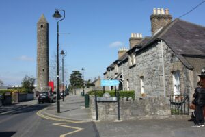
The curve of the road is not an accident of planning or a quirk of suburban development. It is the preserved outline of an early medieval ecclesiastical boundary, roughly 310 metres in diameter, within which a church and a round tower once stood at its approximate centre. That the street plan of a busy Dublin suburb has quietly retained the geometry of an Early Christian monastery is, by itself, a remarkable thing.
The monastery was founded in the seventh century by St Mochua, also known as Cronán, and was already significant enough by the middle of the eighth century for abbots to appear in the annals. In 789, the relics of Mochua were formally translated here, a ceremonial act that signals the site's standing within the Irish church. The Vikings plundered it in 833, and Clondalkin subsequently became a base for Norse activity in the region. A fort was established there by Olaf the White, the first Norwegian king of Dublin, though its exact location has never been confirmed. It appears only once in the historical record, in 867, when it was attacked and burned by two Leinster chieftains, Gaithine's son and Mael Ciarain son of Ronan, with an annalistic entry recording the killing of a hundred Viking leaders nearby. Scholars have noted that Clondalkin may represent one of the very few documented Viking rural settlement sites in Ireland, though the evidence remains frustratingly sparse. The nearby placename Raheen, suggesting a small fort or enclosure, has been floated as a possible clue to the fort's whereabouts. The monastery was burned again in 1071, and in 1077 it passed to the Célí Dé, a reform movement within the Irish church emphasising austerity and communal discipline, before its lands were absorbed into the diocese of Dublin ahead of the Anglo-Norman invasion, a process connected to the church reorganisations that followed the Synods of Rath Breasail in 1111 and Kells in 1152.
The enclosure itself is not marked or interpreted on the ground, which is part of what makes it worth knowing about. The round tower still stands and is the most visible surviving feature of the early monastery. To appreciate the scale of the original enclosure, it helps to stand somewhere along Orchard Lane and look at the curve of the road, then to consult an overhead map that shows how Main Street continues that same arc southward. The eastern half of the boundary is legible in this way; the western half has been absorbed into the surrounding streetscape and is no longer readable at ground level. There is no particular season that improves the experience, and no special access is required.