The curving arc of Orchard Lane preserves the boundary of a seventh-century monastic enclosure. A crenellated tower from the sixteenth century still stands on the south side of the road. And somewhere beneath or near the modern suburb, archaeologists believe, lies one of the very few recorded Viking rural settlement sites in Ireland, its exact location still unknown.
The place takes its name from the Irish Cluain Dolcáin, meaning Dolcán's Meadow, and its recorded history begins with the foundation of a monastery by St Mochua, also known as Cronan, in the seventh century. The relics of Mochua were brought here in 789, and by 833 the monastery was considered significant enough to be plundered by Vikings. What followed is particularly unusual. A fort was established at Clondalkin by Olaf the White, the first Norwegian king of Dublin, and the annals record its violent end in 867, when two Leinster chieftains burned it and killed a hundred of the Norse leaders in the vicinity. Whether the Vikings had fortified the monastery itself, as they appear to have done at sites such as Monasterboice and St Mullin's, or built separately nearby, is unresolved. The placename Raheen, close to the monastic site, may be a clue. After this period of Norse activity the monastery passed to the Célí Dé, a reform movement within the Irish church, and the lands were eventually absorbed into the diocese of Dublin before the Anglo-Norman invasion. Under Norman archbishops, Clondalkin became the centre of one of the largest manors of the metropolitan see, and a borough grew up alongside it, governed by a corporation and bailiff; by 1276 that office was held by a man named Robert Beg. A 1326 survey records thirty-two and two-thirds burgages and describes the archbishop's house as a chapel and chamber badly roofed with shingles, a stone stable, and two thatched outbuildings that nobody wished to inhabit. By the close of the fourteenth century the borough had at least five named streets, among them Mill Street, Steeple Street, and Pope Lane. The Confederate Wars of the 1640s burned the village back almost to nothing; the Down Survey of 1657 found only a castle stump, thatched houses, and the round tower.
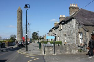
The round tower still stands near St Cronan's parish church and is the most visible marker of the early monastic site. The triangular market place once occupied the junction of Main Street and Monastery Road, and that junction is still there. Tully's Castle, the narrow two-storey crenellated tower on Monastery Road, survives as the most legible fragment of the medieval borough. When the antiquarian Austin Cooper visited in 1780 he found the village small but noted it then contained more ancient remains than survive today, which gives some sense of how much has been lost to subsequent centuries of building.