Bridge, Dublin South City, Co. Dublin
Co. Dublin |
Bridges & Crossings
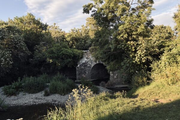
The bridge that once carried travellers across the Liffey at Kilmainham has entirely vanished from the landscape, yet the spot where it stood has been in near-continuous use as a crossing point for the better part of six centuries.
What most people walking across Sarah Bridge today do not realise is that they are passing over a location where people have been fording, then bridging, the river since at least the mid-fifteenth century.
The history of this crossing is one of repeated loss and rebuilding. A stone bridge was constructed here in the mid-1400s, only to be swept away by a flood in 1545, according to the scholar Litton-Falkiner writing in 1904. A replacement was built in 1577, at a natural fording point recorded under the name 'Kilmehanoc', and this became known as Kilmainham Bridge. It was a substantial structure, with eight unequal arched spans crossing the Liffey, and it appears on the Down Survey maps of 1655 to 1656, annotated simply as 'An arched stone Bridge cross the River Liffey'. The Down Survey, commissioned under Oliver Cromwell to document and redistribute Irish land, is one of the earliest systematic cartographic records of the country, and the fact that Kilmainham Bridge merited a label on those maps suggests it was considered a significant crossing at the time. The bridge survived for over two centuries before collapsing in the late eighteenth century, after which it was replaced by Sarah Bridge, the elegant single-arch structure that stands at the site today.
Sarah Bridge, now more commonly known as Islandbridge, sits just west of the city centre and is accessible on foot or by bicycle along the south quays. The river here is quiet compared to the busier crossings downstream, and the surrounding area includes the War Memorial Gardens on the north bank. There is nothing visible above ground to mark where the older Kilmainham Bridge once stood, but the continuity of use at this particular bend in the Liffey, from medieval ford to flood-lost stone arch to the present crossing, gives the location a quiet depth that is easy to overlook.
Ref: DU01208
Nearby Places
Visitor Notes
Added by
