
Bridge, Westown, Co. Dublin
Co. Dublin |
Bridges & Crossings
A double-arched bridge over the River Delvin near the village of Naul might not stop many travellers, but the crossing point it occupies has been documented for nearly four centuries, and the river it spans was once known by an entirely different name.
Seventeenth-century maps label it the River Elfin, and it is under that name that the bridge first appears in the historical record, carrying traffic along one of the main northern routes out of Dublin.
The Down Survey, a vast cartographic project directed by William Petty in the 1650s, recorded the bridge on its parish map of Naul, produced in 1655 to 1656. The survey, which aimed to document landholdings across Ireland following the Cromwellian settlement, named it 'Paul [Naul] Bridge' and placed it on the principal road running north from Swords, through Rathbeale and Roganstown, past the Naul and Dardistown, and on towards Drogheda. The parish map shows the bridge sitting to the east of a watermill located in the County Meath portion of the area, roughly where Naul Park House stands today. The accompanying terrier, a written description of the mapped features, noted the River Elfin as having 'a Mill in Repaire, in the Towneland of the Naule, and a Bridge over the Said River', a phrase preserved in NLI MS 714, the parish maps of the Down Survey for County Dublin, which were attested by Petty in 1657 and later copied by Daniel O'Brien between 1786 and 1787. The barony map of Balrothery adds a further reference, labelling the crossing 'The Naule Bridg' alongside the mill on the River of Elfin.
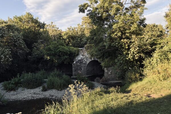
The bridge visible today is not the seventeenth-century structure itself, but it occupies the same site. It carries two round segmental arches, a form in which the arch describes less than a full semicircle, and the stonework shows dressed detail around the arches. The location can be approached via the village of Naul in north County Dublin, close to the border with Meath. Those with an interest in early Irish cartography may find it worth consulting Rocque's 1760 map of County Dublin alongside the Down Survey materials, both of which are available through Irish digital collections, to trace how this modest crossing was recorded across different periods. The riverbank setting is quietly useful for orienting yourself against the older maps, where the mill and bridge appear side by side on the Elfin, a name that has otherwise vanished from the landscape entirely.
Ref: DU00104
04-Essential
Nearby Places
Visitor Notes
Added by

Pete F
Hibernia Regnum: A set of 214 barony maps of Ireland dating to the period AD 1655-59. The original parish maps have been lost but the Hibernia Regnum maps are preserved in the Bibliotheque Nationale, Paris (Goblet 1932, v-x). Photographic facsimiles of these maps were published by the Ordnance Survey, Southampton in 1908.
Rocque, J. 1760 An Actual Survey of the County of Dublin, on the same Scale, as those of Middlesex, Oxford, Berks and Buckinghamshire. Available at http://sdublincoco.maps.arcgis.com/apps/webappviewer/index.html?id=e0c5595b033341dea7661e248d2e9ee9// [Accessed 21 September 2016]