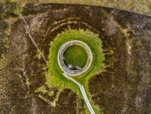
This oval earthwork stretches 28.8 metres from northeast to southwest and 35.8 metres from northwest to southeast, its boundaries marked by a low bank that rises just half a metre above the surrounding landscape. While the exterior bank is clearly visible, the interior sits level with the enclosed area, creating a distinctive defensive feature that would have once protected an early medieval farmstead.
Ringforts like this one were the most common type of settlement in Ireland between roughly 500 and 1100 AD, serving as fortified homesteads for farming families. The earthen bank would have originally been topped with a wooden palisade, enclosing houses, storage buildings, and livestock pens. Though now reduced to gentle undulations in the pasture, this rath represents the everyday lives of ordinary people during Ireland's early historic period, when cattle were wealth and community defence was paramount.
The site was documented as part of the comprehensive Archaeological Survey of County Donegal, compiled by Brian Lacey and his team in 1983. This ambitious project catalogued field antiquities spanning from the Mesolithic period through to the 17th century, ensuring that even modest monuments like this Bunnamayne ringfort were properly recorded. Today, the rath continues to mark the landscape much as it has for over a millennium, a quiet reminder of the farming communities who once shaped these fields.